Tour: Nacimiento-Ferguson Road to Highway 1
by Mr. Spice and MzRAD
“You can’t camp here,” they said, looking at our bike camping bivouac in the middle of their military base. The two police officers from Fort Hunter Liggett—50 miles north of Paso Robles in the rural foothills of the Santa Lucia Range—were ruining my thoughts of a restful sleep tucked in the tent with my sweetie.
I actually should thank them for giving us the chance to check out The Hacienda, William Randolph Hearst’s old hunting lodge at Fort Hunter Liggett and preventing us from ending up stuck in some tank treads as the army played war games around us in the dark. With the closest campsite a dozen miles down the unlit road, we headed back to the well-lit base to see if we could wrangle a room at The Hacienda. Such was the first night of our tour over the Santa Lucia Range and through Big Sur via Nacimiento-Ferguson Road and Highway 1.

click for map
Hearst’s Humble Hacienda

The Hacienda at Fort Hunter Liggett
Before the police officers suggested we decamp to The Hacienda, a couple of good friends had already brought this place to my attention when we talked about local adventures in San Luis Obispo County. Pre-9/11, they had spent a romantic weekend here, enjoying hikes in the hills right out the front door and exploring the nearby Mission San Antonio. Now, of course, you have to check in through the front gate with the proper ID and you’re reminded not to go poking around the base or taking pictures of any military structures or equipment.

Mission San Antonio de Padua, founded 1771
Normally to stay at Hearst’s Hacienda, you need to make reservations a couple of weeks in advance. We can’t recommend our method of arriving at the dark office at 7pm, reaching the manager on her cell phone, and begging for a room because we didn’t want to ride our bikes in the dark with inadequate lights 12 miles to the next real campground. But it worked!
While not the lap of luxury it was during Hearst’s heyday, The Hacienda is still pretty cool: historical, comfortable, reasonably-priced and managed by nice people who let you take bikes into the room. We stayed in one of the “cowboy rooms” ($50/night) which means you share a bathroom at the corner of the building.
Climbing Nacimiento-Ferguson Road
After a nice continental breakfast, we set off with loaded panniers, inflated tires, and high hopes for our day, which consisted of climbing 2,677 feet to cross the southern Santa Lucia Mountains. Nacimiento-Ferguson was everything we hoped for in a road ride: nice rolling hills, oaks dappling the countryside, and a reasonably wide shoulder. The traffic for a late autumn weekday was almost non-existent: only one caravan of personnel carriers and HumVees passed us as they headed out to do their exercises. Finally, we passed the canvas arches that indicated the boundary of Fort Hunter Liggett, which is how far you have to go before camping. Lesson learned: no bivouacking on the military base, so have a plan to get to legal camping by nightfall.
Heading west on Nacimiento-Ferguson Road in late fall is amazing. The rolling hills turn into forested mountainsides although reaching the top of this climb doesn’t require any heroics. Crossing the Santa Lucia Range was nowhere near as challenging as we had expected. The worst thing about it all was trying to stay ahead of the 6 mile-an-hour flies. Never especially steep, this climb requires cyclists’ attention to the cars traveling this very curvy road without a guardrail.

Big Sur south of Cone Peak
From the top of the hill, dense trees cloud the view of the ocean. At its summit, Nacimiento-Ferguson Road bisects a dirt road: the way north heads to Cone Peak (6 miles one way) and heads south along Plaskett Ridge for bivouac camping. No water or facilities in either direction but plenty of views.

check breaks and hub skewers for peace of mind on the descent
Saving hiking and ridge-top camping for another trip, with the Pacific in sight we gleefully but cautiously dropped toward Highway 1 and Big Sur. We enjoyed the crazy ride down: hairpin turns and no shoulder but multiple lookouts over the fogbank rising from the Pacific. Then, near the bottom of the hill, we’re enveloped in the fog and its all you can do to keep the sudden cold from stealing your grip from the brakes. “Hopefully the cars in front of me stay on their side of the road or are going fast enough so I don’t run over the top of them,” we think as we zoom downhill. Personally, we enjoyed the shorter climb followed by a longer descent, which is what you get when you travel east to west, although plenty of crazy cyclists relish starting their climb at Highway 1 and riding east.
Foodies on the Highway 1

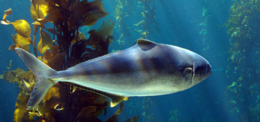
Treebones Resort: look for the fish
Nacimiento-Ferguson Road plummets toward the Pacific Coast Highway and lands just above Kirk Creek Campground, which has hiker-biker campsites available. Although Big Sur to the north offers several foodie options such as the Big Sur Bakery and Nepenthe, we were headed south.
Having only pedaled 30 miles or so since we headed out in the morning, we head toward Plaskett Creek Campground, which also has hiker-biker facilities and nice bathrooms but no showers. We set up camp, connect with some other through-cyclists, and head to Treebones Resort a couple miles south of the campground, which we heard offered the best sushi in Big Sur.
Treebones not only had great sushi, they had fantastic sushi and sake as well as dinner entrees and wine at their Wild Coast restaurant. Yes, you can eat this much when you’re bike touring. Metabolism! Although we were set up in the campground on this trip, we’re quite intrigued by the yurts at Treebones and are considering another trip where we forgo the tent altogether. While waiting for the first-come, first-serve sushi bar to open, we visited their working organic garden cultivated with flowers, squash, greens, and more edibles, terraced into fog.
Eighty Miles from Home, Forty to Lunch
The next morning, the cool, moisture-laden Pacific coast air kept us in our sleeping bags a little longer than we planned for this big day: we had an 80 mile day ahead of us. “I don’t remember this many hills!” hollered Rachel from a ways back as we turned another uphill corner and saw even more uphill to climb. Yes, the Pacific Coast Highway at Big Sur delivers hills: you keep climbing over things that should have tumbled into the Pacific Ocean a long time ago: damn tectonic plates.

Robin’s Restaurant in Cambria
After Ragged Point, the road flattened out and the tailwind picked up. Fully loaded, we cruised south at 17-miles an hour, no sweat, for a long time. Wind-riffled grasses broke toward beaches full of elephant seals. Did the thought of lunch and dessert at Robin’s Restaurant keep us moving through southern Big Sur? Cambria: the perfect halfway point for a foodie refuel during our long ride home.
The really nice people at Robin’s helped us with parking our bikes near a window so we could keep an eye on the bags. “We get cyclists all the time,” says the hostess. Nice to feel welcome rather than weird, even in Spandex and especially when you’ve eaten Big Sur hills for breakfast. The lunch feeding frenzy begins: appetizers and a couple of entrees disappear before we remember to take a picture. Finally, we manage a photo of our delicious desserts before devouring them, too.

chocolate raspberry dessert at Robin’s
We head out, wind at our backs and cruise toward Morro Bay, headed for home. Saddle sour, happy and tired, we pull back into our cool little SLO town after this fun, short bike trip full of beautiful landscapes, great food, and good people.